 Secure Payment
 Free shipping on orders over €60 (UE)
 Financing on orders over € 50
 Hassle-free returns
-
Land: The software for nature lovers
Land is an agile and powerful tool to create and analyze your routes on the best maps. Prepare your outdoor activities and upload them to your GPS device or smartphone, all the information you need at your disposal.

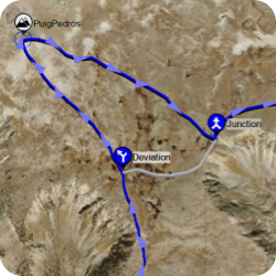
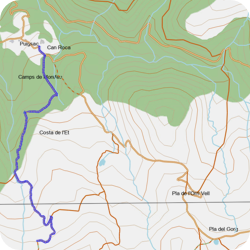
Create the best routes
Prepare your routes in detail to fully enjoy your activities without forgetting safety

Work on the best maps
Having good maps is key to adapt yourself to an unknown terrain the best possible way

Weather forecast
Check the weather forecast several days in advance so you can adjust your schedule to the local weather.

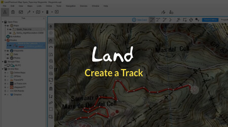
Create the best routes
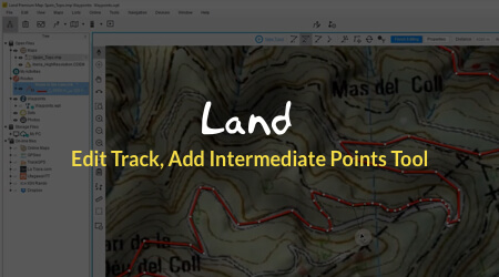
Load routes, join multiple routes, or create them from scratch. Follow the paths on the map, or draw your own offroad route. Enrich your tracks with all the information you will need during the activity.
-
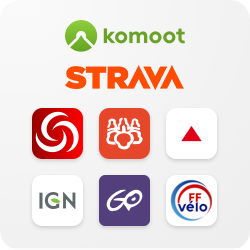
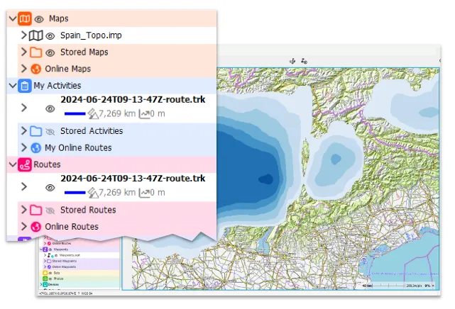
Open routes from any source
Use files from any source, Land is compatible with multiple formats (*.GPX, *.FIT, *.KML...). You can download routes for the area you want to visit from important providers like Komoot, Wikiloc, OpenRunner, UtagawaVTT, IGN Rando and even... from other TwoNav users!
-
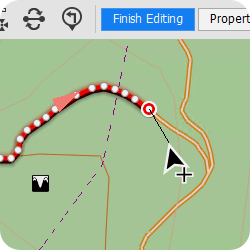
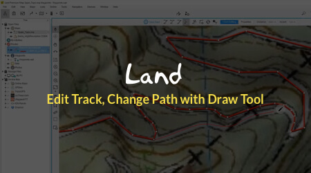
Modify and adapt your routes
Create routes in the most agile way, whether point to point or freehand drawing. You can also use existing routes to modify their paths according to your needs: cut the sections of the route that don't interest you, join parts of other routes, or extend them as far as you want.
-
 New
New
Weather forecast
Get informed about the weather forecast while planning your route. Check the weather forecast for a specific location several days in advance or, if you prefer, consult specialized weather maps with information on precipitation, cloud cover, wind...
-
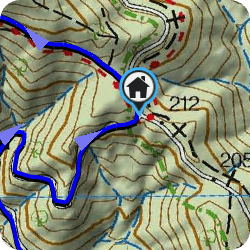
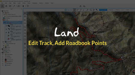
Roadbooks
Enrich your routes with extra information on the most relevant points, whether they are maneuvers or points of interest. Add reminders and important information on your route, in the form of an icon, sketch, text, image or sound
-
Variants
Prepare different alternatives to adapt your itinerary to any unforeseen event: fatigue, road conditions, weather... Add shortcuts to your routes or optional visits to points of interest on the same track
-
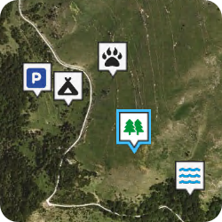
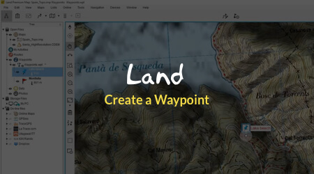
Waypoints
Mark your points of interest on the map and organize them into collections to find them easily. You can import waypoints or create them yourself, either on the map or by entering coordinates. Attach text, image or sound to have all the information you need

Open routes from any source
Use files from any source, Land is compatible with multiple formats (*.GPX, *.FIT, *.KML...). You can download routes for the area you want to visit from important providers like Komoot, Wikiloc, OpenRunner, UtagawaVTT, IGN Rando and even... from other TwoNav users!

Modify and adapt your routes
Create routes in the most agile way, whether point to point or freehand drawing. You can also use existing routes to modify their paths according to your needs: cut the sections of the route that don't interest you, join parts of other routes, or extend them as far as you want
 New
New
Weather forecast
Get informed about the weather forecast while planning your route. Check the weather forecast for a specific location several days in advance or, if you prefer, consult specialized weather maps with information on precipitation, cloud cover, wind...

Roadbooks
Enrich your routes with extra information on the most relevant points, whether they are maneuvers or points of interest. Add reminders and important information on your route, in the form of an icon, sketch, text, image or sound

Variants
Prepare different alternatives to adapt your itinerary to any unforeseen event: fatigue, road conditions, weather... Add shortcuts to your routes or optional visits to points of interest on the same track

Waypoints
Mark your points of interest on the map and organize them into collections to find them easily. You can import waypoints or create them yourself, either on the map or by entering coordinates. Attach text, image or sound to have all the information you need

Work on the best maps
Topographic maps, satellite images, 3D relief... use all kinds of maps from the best publishers from around the world, or... create your own!
-
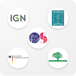
High-quality maps from around the world
If you don't have maps, Land provides them to you for free. In addition, TwoNav has agreements with major publishers so you can also access the best paid cartography: from official institutions in the UK (Ordnance Survey), France (IGN), Germany (BKG) or Spain (IGN) to publishers specializing in hiking areas (OSM, Alpina, Fraternali...)
-
Compatibility with a multitude of formats
If you have your own map sources, you can also use them if they are in any of the compatible formats (*.ECW, *.SID, *.SHP, *.IMP...). Topographic maps, satellite images, reliefs, online maps... Land allows you to work with any type of map
-
 New
New
OpenStreetMap world coverage map included
Here you will find the most important urban roads and mountain paths of each country. Use it to create your routes in just a few clicks, simply mark the starting and ending points. The FastTrack feature will generate your route and add waypoints at the most important maneuvers of the itinerary
-
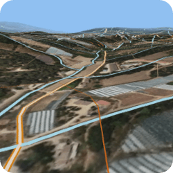
Combine them as you want
Open different maps at the same time and get the best out of each one. You can show or hide them, rearrange their layers, add transparency or view them in 3D. Everything in an agile and comfortable way so that you have the best information at all times
-
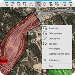
Create your own maps
In addition to opening any type of map, Land allows you to create them in different ways. You can create a vector map from scratch, capture an area from an online map, digitize a paper map, or cut and stitch maps
-
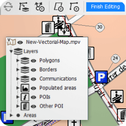
Professional editing tools
Edit vector maps with advanced tools to control every last detail. Modify the layout of objects, organize them by layers, copy and paste layers and objects from other maps, modify color, thickness, transparency, zoom levels... and much more

High-quality maps from around the world
If you don't have maps, Land provides them to you for free. In addition, TwoNav has agreements with major publishers so you can also access the best paid cartography: from official institutions in the UK (Ordnance Survey), France (IGN), Germany (BKG) or Spain (IGN) to publishers specializing in hiking areas (OSM, Alpina, Fraternali...)

Compatibility with a multitude of formats
If you have your own map sources, you can also use them if they are in any of the compatible formats (*.ECW, *.SID, *.SHP, *.IMP...). Topographic maps, satellite images, reliefs, online maps... Land allows you to work with any type of map
 New
New
OpenStreetMap world coverage map included
Here you will find the most important urban roads and mountain paths of each country. Use it to create your routes in just a few clicks, simply mark the starting and ending points. The FastTrack feature will generate your route and add waypoints at the most important maneuvers of the itinerary

Combine them as you want
Open different maps at the same time and get the best out of each one. You can show or hide them, rearrange their layers, add transparency or view them in 3D. Everything in an agile and comfortable way so that you have the best information at all times

Create your own maps
In addition to opening any type of map, Land allows you to create them in different ways. You can create a vector map from scratch, capture an area from an online map, digitize a paper map, or cut and stitch maps

Professional editing tools
Edit vector maps with advanced tools to control every last detail. Modify the layout of objects, organize them by layers, copy and paste layers and objects from other maps, modify color, thickness, transparency, zoom levels... and much more

Control down to the last detail
Analyze information from all imaginable perspectives, in numbers, graphs or colors. Measure your activities in detail to get the most out of them.
-
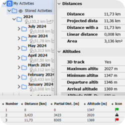
Measure everything
Distances, altitudes, times, directions... Land has innumerable data calculated on tracks, waypoints or maps. Measure your routes and activities with maximum precision, either globally, by sections or point to point
-
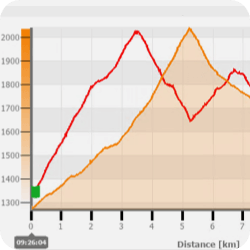
Graphic analysis
Land has a powerful graphics system that allows you to have a clear view of parameters such as altitude, speed or heart rate. You can also compare several tracks at the same time, or combine several parameters in a single graph
-
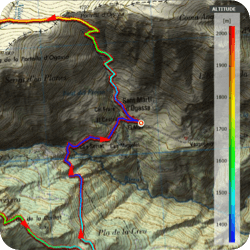
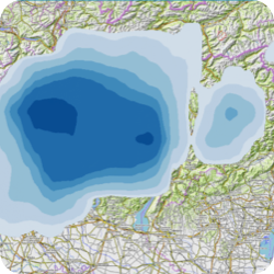
Color gradient
The coloring of the tracks according to various parameters will give you another dimension of analysis on the map, so you can quickly locate key points such as heart rate or slope spikes
-
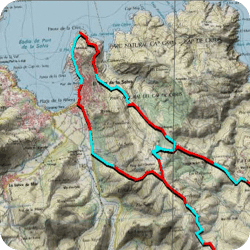
Laps and Subtracks
A route is not a monotonous path. With Land you will be able to analyze specific sections of the tracks, and mark the sections that you want to distinguish permanently. You can also divide them automatically by time or distance
-
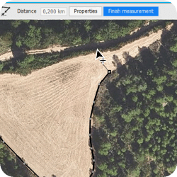
Distance measurement
Quickly measure any distance on the map, both in a straight line and by adding various points and editing them. Move the mouse and Land will indicate the distance in real time
-
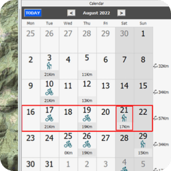
Calendar
Your activities and other created files will be displayed in a practical calendar view, access it to recover any of your outdoor activities. Check statistics and data for certain periods of time

Measure everything
Distances, altitudes, times, directions... Land has innumerable data calculated on tracks, waypoints or maps. Measure your routes and activities with maximum precision, either globally, by sections or point to point

Graphic analysis
Land has a powerful graphics system that allows you to have a clear view of parameters such as altitude, speed or heart rate. You can also compare several tracks at the same time, or combine several parameters in a single graph

Color gradient
The coloring of the tracks according to various parameters will give you another dimension of analysis on the map, so you can quickly locate key points such as heart rate or slope spikes

Laps and Subtracks
A route is not a monotonous path. With Land you will be able to analyze specific sections of the tracks, and mark the sections that you want to distinguish permanently. You can also divide them automatically by time or distance

Distance measurement
Quickly measure any distance on the map, both in a straight line and by adding various points and editing them. Move the mouse and Land will indicate the distance in real time

Calendar
Your activities and other created files will be displayed in a practical calendar view, access it to recover any of your outdoor activities. Check statistics and data for certain periods of time

Land 10: Discover all the new features of the new version
Land 10 arrives full of new features designed to ensure your safety on any terrain you set out to discover. Plan and analyze your routes with greater ease using new tools that you'll only find in this update: new interface and data tree, new included maps, weather forecast... and much more!
See all the new features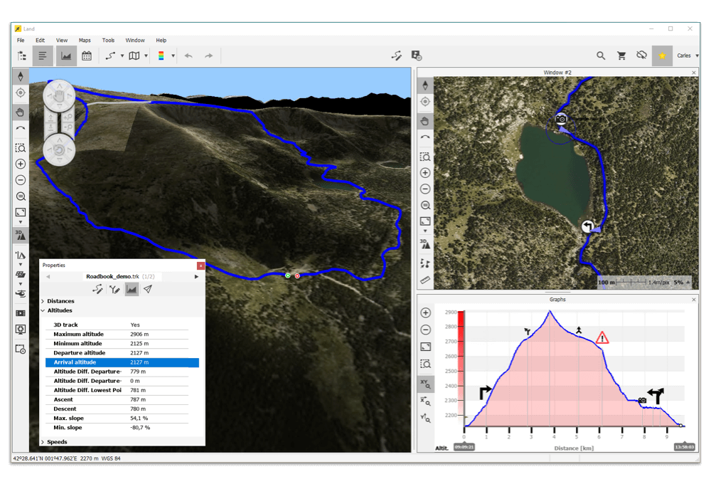
Land adapts to you
Land is ready to use, but each user is unique and different, so Land allows you to make all the adjustments to make it yours. Arrange the windows as you like, edit the button and menu bars, select your favorite files, configure the graphics, icon collections, organize your routes and activities by folders to easily consult them or even the quick functions of the keys.
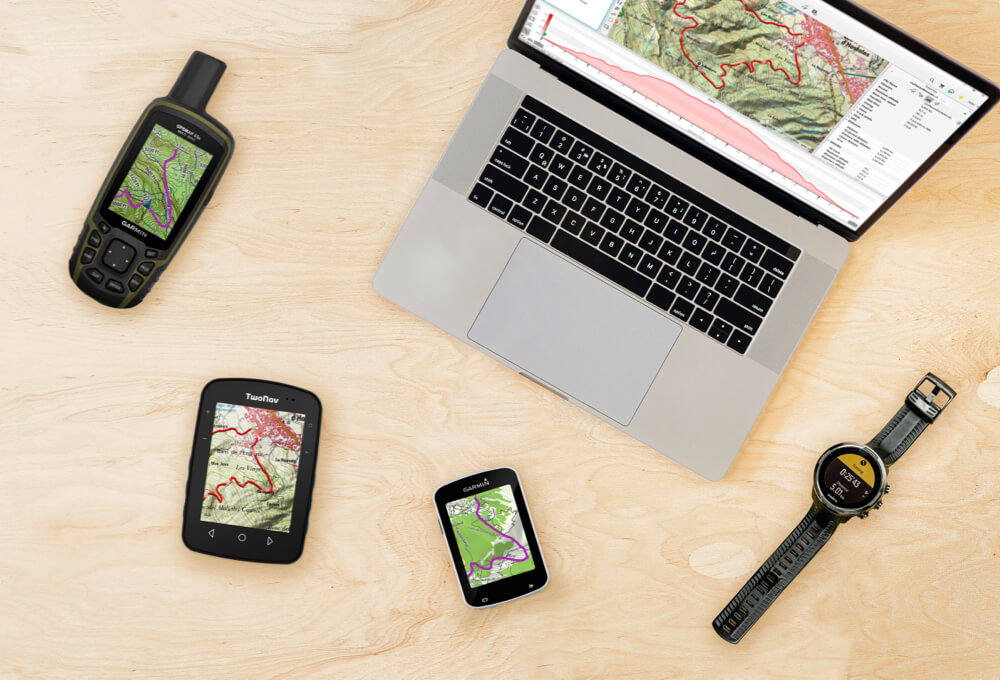
Compatibility with all types of GPS devices
You can use all the material you prepare in Land during your activities with any GPS device or smartphone so that it alerts you at key moments or if you deviate from your route. In addition, with TwoNav GPS or App TwoNav you can even transfer maps to have all the resources at your fingertips during the activity.
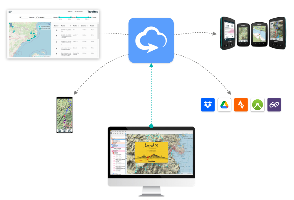
Connect everything with the GO™ Cloud
The TwoNav ecosystem centralizes your files in the GO™ Cloud so that you have them available at any time and place, be it on your computer, GPS device or smartphone. In addition, the GO™ Cloud allows you to connect with services such as Strava™, Komoot™, DropBox™ or Google Drive™ to get the most out of all of them.
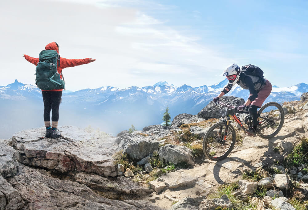
What is your outdoor activity?
Land is used by countless cyclists and hikers around the world as it is perfectly suited to all kinds of outdoor activities: hiking, mountaineering, geocaching, MTB, enduro, kayaking, sailing, motorcycling, 4x4, paragliding, hang gliding...
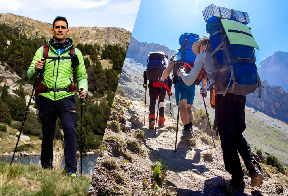
No matter your level, Land is designed for all users
You can use Land whether you are an occasional hiker looking for weekend routes, or an expert mountaineer or mountain guide planning and evaluating multi-day routes for groups.
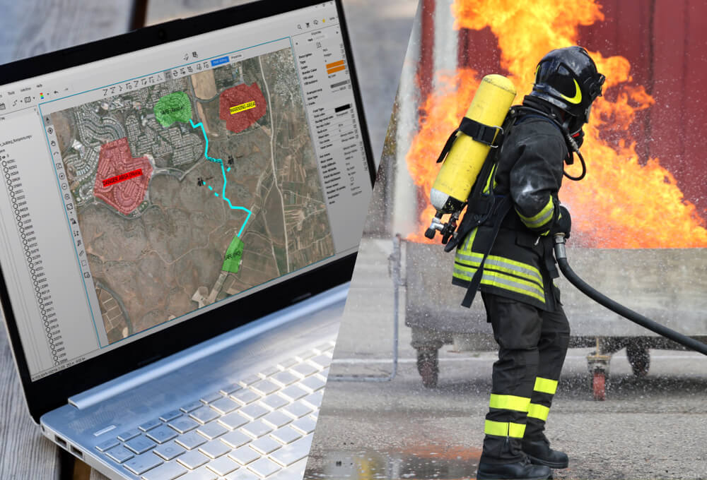
Also used by professionals
Land's power and flexibility make it a reference tool for many professionals from different sectors. Rescue services, security forces, forest technicians, training schools... TwoNav works together with all of them to meet the most demanding needs.
TRY IT FREE NOW
What better way to get to know Land than to try all its features yourself

This software uses libraries from the FFmpeg project under LGPLv2.1.
DISCOVER THE TWONAV SUBSCRIPTION PLANS
Experience more for less. Try PRO for free for 30 days
Try PRO features for 30 days for free. Once over, BASIC plan will be activated. No credit card required
Basic
$0Try PRO features for 30 days for free.
No credit card required
Premium
- All the BASIC advantages
- Land advanced features:
- Tracks edition
- 3D mode
- Navigation
- Raster maps edition
- TwoNav navigation app with advanced functions
- Maps included:
- Routable OSM maps (offline)
- Maps Plus (online)
- Meteorology:
- Forecast by location
- Unlimited updates
- Activation up to 5 devices
- GO Cloud 1 GB
Cancel anytime
Automatically renewed until cancelled
Pro
- All the BASIC advantages
- All the PREMIUM advantages
- Land professional functions:
- Vectorial maps edition
- Creation of hypermaps
- TwoNav navigation app with advanced functions
- Maps included:
- Routable OSM maps (offline)
- Maps Plus (online)
- Meteorology:
- Forecast by location
- Weather maps (rain, cloudiness, wind)
- Unlimited updates
- Activation up to 5 devices
- GO Cloud 5 GB
Cancel anytime
Automatically renewed until cancelled
License Land 10
- Land basic features
- Land advanced features
- Land professional functions
- Maps included:
- Different types of maps (online)
- Routable OSM maps (offline)
- Land 10.X updates included
- Activation up to 3 devices
- GO Cloud 1 GB
(Maps Plus not included) - Meteorology (for 1 year):
- Forecast by location
- Weather maps (rain, cloudiness, wind)
LAUNCH OFFER:
Single payment subject only to Land 10 version
App Nav 5
GO Cloud 250MB

Check it out for yourself


Know the opinion of the specialized press
-

For all kinds of sportmen
Land is the perfect software for all those cycling or mountaineering fans who want to explore new routes with maximum precision and safety, whether it be hiking, mountaineering, mountain biking, gravel, road or even bikepacking
Solo Bici
Spain -
Lots of maps
The strongest point of Land is the multitude of maps that the software provides you with. The cartography is extremely complete, you can find almost all the maps of the world. The accuracy of the maps is excellent, therefore creating precise routes is very easy. Also, overlapping them is very practical if you are preparing a route that spans several countries. You can use the maps on all TwoNav ecosystem devices: Land, GPS and the App
i-Trekkings
France -

Very useful to create variants in your routes
It is very practical that a route can contain different variants, so that you can have several alternatives for the same route. For example, a longer and a shorter route variant, or a variant with optional stops at certain places of interest. In addition, the routes calendar has a view in which routes, waypoints and activities can be displayed according to their creation date
Pocket Navigation
Germany -
Itineraries with the maximum detail
Land is agility, control and route analysis. Adventures are often done twice: when you plan it and when you enjoy it on the ground. Land allows us to enjoy the experience of preparing the route comfortably from home with the feeling of knowing the terrain
El Blog de Alakan
Spain


-
For all kinds of sportmen
Land is the perfect software for all those cycling or mountaineering fans who want to explore new routes with maximum precision and safety, whether it be hiking, mountaineering, mountain biking, gravel, road or even bikepacking
Solo Bici
Spain -
Lots of maps
The strongest point of Land is the multitude of maps that the software provides you with. The cartography is extremely complete, you can find almost all the maps of the world. The accuracy of the maps is excellent, therefore creating precise routes is very easy. Also, overlapping them is very practical if you are preparing a route that spans several countries. You can use the maps on all TwoNav ecosystem devices: Land, GPS and the App
i-Trekkings
France -
Very useful to create variants in your routes
It is very practical that a route can contain different variants, so that you can have several alternatives for the same route. For example, a longer and a shorter route variant, or a variant with optional stops at certain places of interest. In addition, the routes calendar has a view in which routes, waypoints and activities can be displayed according to their creation date
Pocket Navigation
Germany -
Itineraries with the maximum detail
Land is agility, control and route analysis. Adventures are often done twice: when you plan it and when you enjoy it on the ground. Land allows us to enjoy the experience of preparing the route comfortably from home with the feeling of knowing the terrain
El Blog de Alakan
Spain
 Secure Payment
 Free shipping on orders over €60 (EU)
 Hassle-free returns