 Pago seguro
 Envío gratuito por compras superiores a 60 € (UE)
 Devolución sin compromiso
Este fin de semana desconecto de todo, ¡menos de mi ruta!
Aprende a preparar tus actividades con precisión y a navegarlas con seguridad
¡Hola! Soy XXXXX, tengo 47 años y soy un gran aficionado a explorar la montaña.
Para este fin de semana me he propuesto descubrir una zona nueva que llevo tiempo queriendo explorar. No la conozco, así que quiero preparar mi ruta sin complicarme con la tranquilidad de saber que todo está bajo control. Lo haré con las herramientas del Ecosistema TwoNav.
Durante esta formación te explicaré de una forma práctica y sencilla lo más importante que debes tener en cuenta en cada fase de tu actividad: Preparación de la ruta entre semana con el planificador de rutas Land. Salir a navegar la ruta el fin de semana con la App TwoNav o un GPS TwoNav. Y, al llegar a casa, compartir la ruta con otros aficionados con TwoNav Cloud.
-
-

Ana Bohueles
Aficionada al senderismo y MTB -

Ana Bohueles
Aficionada al senderismo y MTB
Si aún no has probado estas herramientas, activa ahora tu Prueba Gratuita que te da acceso a Land, app TwoNav y TwoNav Cloud.

En búsqueda de inspiración
Como no conozco la zona, en lugar de ponerme a dibujar el trazado de mi itinerario desde cero, para ganar en seguridad y empezar con buen pie, me basaré en recorridos de otros usuarios por esta zona. Al tratarse de una zona nueva para mi, necesitaré encontrar mapas detallados y fiables para poder trabajar mi recorrido en Land. Hay muchos tipos de mapas, usaré los mapas que me aporten más información para conocer mejor el lugar por el que me voy a mover. Una vez tenga el mapa y haya elegido mi recorrido, crearé una pequeña base de datos con los puntos de interés más importantes de la zona, así tendré referencias del lugar y cuando salga a explorar la zona me orientaré más fácilmente y tendré un mejor conocimiento del lugar.
Descargar rutas de Wikiloc y Komoot
Hay muchos aficionados que ya han estado allí antes que yo y han recorrido esos senderos, así que aprovecho su experiencia y me conecto a Komoot y Wikiloc para comparar recorridos.
Además de Komoot y Wikiloc, Land también me da acceso a otros servidores online de rutas donde también echaré un ojo y buscaré rutas de mi zona. No se trata de copiar sin más, sino de encontrar una buena base sobre la que construiré mi propio itinerario.
Te enseño cómo hacerlo en varios tutoriales:
Encontrar el mapa más adecuado para mi zona
Durante la preparación del recorrido es vital estudiar la zona sobre la cual vamos a crear la ruta. Un consejo: nada más empezar, hazte con una buena base cartográfica del lugar.
Si eres nuevo en esto de los mapas, te recomiendo conocer los diferentes tipos, así sabrás cual es el mejor para tus rutas.
Te enseño cómo hacerlo en varios tutoriales:
Te enseño cómo hacerlo en varios tutoriales:
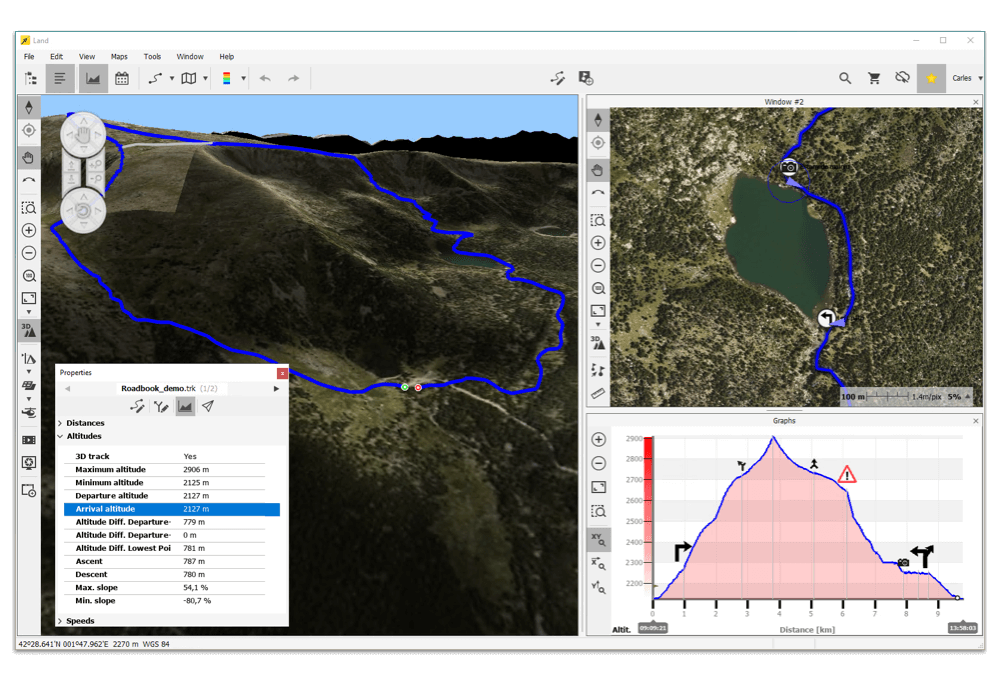
Marcar waypoints cercanos a mi ruta
Una vez tengo el mapa adecuado y el recorrido definido, creo una pequeña base de datos con los puntos de interés más relevantes de la zona: fuentes, cruces, refugios, miradores o cualquier referencia útil.
De este modo, cuando salga a explorar, tendré información clave siempre a mano, me orientaré con mayor facilidad y conoceré mejor el entorno por el que me muevo.
Te enseño cómo hacerlo en varios tutoriales:
Siguiente fase
30% en Suscripciones
Todo lo que necesitas para disfrutar de la montaña de principio a fin

desde sólo XX,XX €/año 29,99 €/añosólo para usuarios sin suscripción
SUSCRIBIRSE
Adaptar el recorrido a mi
Carrusel 2
XXXXXXXX
XXXXX
XXXXXXX
Te enseño cómo hacerlo en varios tutoriales:
Te enseño cómo hacerlo en varios tutoriales:
XXXXXXXX
XXXXX
XXXXXXX
Te enseño cómo hacerlo en varios tutoriales:
Te enseño cómo hacerlo en varios tutoriales:
Siguiente fase
30% en Mapas seleccionados
Te proporcionamos el mapa más detallado para tu próxima aventura. Podrás usarlo en Land, en la App TwoNav y en un GPS TwoNav

+30.000 mapas de todo el mundo
COMPRAR
Análisis del recorrido y su dificultad
Carrusel 3
XXXXXXXX
XXXXX
XXXXXXX
Te enseño cómo hacerlo en varios tutoriales:
Te enseño cómo hacerlo en varios tutoriales:
XXXXXXXX
XXXXX
XXXXXXX
Te enseño cómo hacerlo en varios tutoriales:
Te enseño cómo hacerlo en varios tutoriales:
Siguiente fase
Prepara y analiza tus rutas como un experto
Todas las herramientas bajo una misma suscripción

Disfruta de este conjunto de herramientas y planifica, navega y analiza tus rutas por la montaña con una preparación precisa y detallada. Atrévete a crear rutas por lugares desconocidos y déjate guiar con la seguridad de disponer de mapas fiables y rutas alternativas. No importa tu deporte ni tu nivel, cuando salgas a descubrirlas conocerás tu posición en todo momento y dispondrás de los datos más relevantes en tiempo real: waypoints del lugar, atajos, distancias, altitudes, esfuerzos...
SUSCRIBIRSESiguiente fase:
Salir a navegar la actividad
Sácale aún más partido a Land y la app TwoNav
Sígue formándote con videos, tutoriales y material formativo donde te explicamos paso a paso cómo usar las potentes herramientas del planificador de rutas y la app de navegación
Si tienes alguna duda, ponte en contacto con nuestro centro de soporte, estaremos encantados de ayudarte.
ACCEDER#FreedomToDiscover
